Model type
Classification
Maximum area / minimum area
Max – 1000 sq. km.
Min – 2 sq. km.
Average time of request execution
About 5 minutes
Price
5 $ per 1 sq. km.
Overview
Model description
Provide information to help users understand the current state of the landscape. Allows monitoring of the temporal dynamics of agricultural ecosystems, forest transformations, surface water bodies, etc.
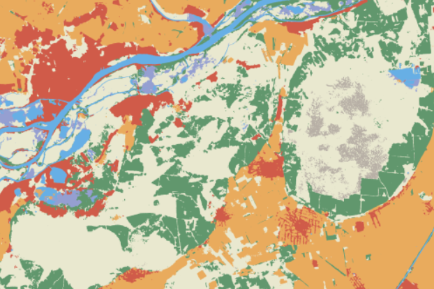
Classes
Water, Trees, Flooded vegetation, Crops, Built Area, Bare ground, Snow/Ice, Clouds, Rangeland.
Selecting the date
To run the model, users need to select a year.
Output
The raster with pixels colored by land use.
Available geographical region
Technical information
Technical description
We provide the ability to view the Sentinel-2 Land Cover from ESRI. The results with resolution 10 m/pix are provided for 11 classes (“Water”, “Trees”, “Flooded vegetation”, “Crops”, “Built Area”, “Bare ground”, “Snow/Ice”, “Clouds”, “Rangeland”).
Spatial resolution
Spatial resolution: 10m per pixel
Input data sources
Optical: Sentinel-2,
Accuracy
Thematic accuracy: variable, ~90%